Skip to content
Community & Place

We deliver active modes design, sustainable transport and community engagement.

Digital & Spatial Technology

We create efficiencies with our spatial, software development, and digital engineering solutions.

Road Safety

We support positive safety outcomes from the street to the transport network.

Strategy & Planning

Delivering business cases, traffic modelling, economic assessments, and public transport innovation.

Transport Design & Engineering 

We deliver designs through collaboration with practitioners to shape transport solutions.

Land Development

We apply our transport expertise to support clients through the land development process.

CarbonWise

Measure your employee’s commuting emissions.

SafeSystem

A data-driven approach for road safety practitioners to identify risks.


COMING SOON

SafeIntersections
SafePeople
SafeStreets
TrafficFlow

Quickly and easily get detailed traffic and mobility data.

Partner Products

We partner with TomTom and HERE to provide transport and traffic data solutions.


More Products

Discover more of our unique products

Our Insights

Read our insightful blogs providing the latest information and trends.

Featured Projects

The work we do helps inspire positive change.

News

Find out what we are up to. 

Research

Applying our research expertise to provide practical based solutions.

Webinars

We deliver a range of webinars covering industry trends.

Our Team

Our team of skilled professionals provide insightful solutions and empowering advice.

Our Story

Since 2003, we’ve been providing transport solutions in New Zealand and internationally. 

Our Commitment

We’re connected and committed to our people, the community and the environment. 

Our Partners

We work closely with our partners to make a meaningful impact.

Our Awards

We showcase our awards to celebrate our people and clients.

TomTom

We sell and support TomTom’s traffic analytics solutions and location data products in New Zealand, Australia, and Southeast Asia.

TomTom are mapmakers, providing geolocation technology and insights for transport analysts, engineers, and developers. Our experienced team can configure, customise, and advise on the appropriate TomTom products to meet your requirements. 

TomTom Application

About TomTom Traffic Analytics

tomtom logo

TomTom Traffic Analytics tools provide a range of benefits for transport and safety engineers, planners and analysts, marketers, and asset managers. 

Whether your goal is to reduce congestion, identify mobility problems, evaluate investment, or set policy, TomTom Traffic Analytics provides current, and predicted traffic data, enabling you to plan and implement interventions. 

TomTom’s Traffic Analytics is provided through the MOVE portal with online access to the analytical tools.  TomTom’s Traffic Analytics products are available in 80 councils including, New Zealand, Australia, and Southeast Asia, leveraging the TomTom Traffic database which has trillions of data points, and over 60 billion new records being added every day. 

Explore TomTom Traffic Analytics products

TomTom stats
Traffic Stats

TomTom Traffic Stats gives you access to the industry’s largest historical traffic database, providing insights into road speeds, travel times, and traffic density enabling you to identify mobility pain points, assess the impact of road network changes, improve traffic management, and much more. 

Use cases:  

  • Measure reliability of travel times  

  • Analyse speeds on road segments to determine congestion bottlenecks and impacts  

  • Measure the impact of travel time/speeds before and after a change to the road network  

  • Identify the impact of seasonality, events, and incidents on traffic congestion  

  • Provide ground truth driving speeds and travel time data for transportation models 

Features and benefits:  

  • Generate detailed output reports
  • Allows for rapid analysis 24/7
  • Analyse a route or a specific geographical region
Origin Destination Analysis

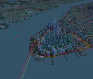
TomTom Origin Destination (O/D) analysis provides detailed information about trip dynamics and drivers’ preferred routes. TomTom O/D Analysis uses advanced algorithms to analyse anonymised GPS data from 600+ million connected devices. Available via the TomTom MOVE portal or API, this solution helps you make better-informed decisions based on how and where people move. 

NewYork_TrafficStats_21Q2_DigitalRGB_1200x1020px-2 REVISED

Use cases:  

  • Calculating the volume of traffic flows between origins and destinations   

  • Determining diurnal and seasonal trip patterns   

  • Understanding preferred routes to/from specific locations  

  • Measuring the historic traffic flows through intersections

Features and benefits:  

  • Allows users to quickly and easily conduct analysis
  • Enables multiple report outputs depending on analysis
  • Analysis can be based on road links or regions
TomTom Traffic Analytics visualization
Junction Analytics

TomTom Junction Analytics helps road authorities, traffic managers and engineers optimise intersection performance with an easy-to-use API and companion web app. Junction Analytics combines real-time traffic data with intuitive analytics tools to help you understand how drivers move through intersections – so you can allocate green time in a better way to cut congestion, reduce pollution, and boost road safety.  

Uses cases for road controlling authorities: 

  • Traffic light optimisation 

  • Intersection optimisation 

  • Improved corridor performance 

  • Real time traffic monitoring 

Features and benefits: 

  • No hardware necessary: Detailed insights into intersection performance, without the need to install or maintain expensive hardware.   

  • Powerful and easy to use: Insights. Fast. Configure and view intersections on a map, validate important road segments and gain new insights into queue length, travel times, turn ratios and more within minutes. 

Route Monitoring

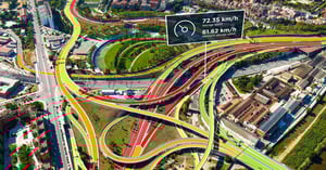
TomTom’s real-time traffic monitoring service makes it easy for road authorities, toll operators, event managers, and emergency services professionals to understand what’s happening on the road. Use the self-service tool to define custom routes and view detailed travel times, speeds, and traffic delays – and take proactive measures to inform drivers and improve mobility. 

TomTom-webimage-8A6CE52C-F46C-4AD3-84FA9EB73C855678

Use cases: 

  • Monitor routes of access and prevent traffic jams for event planners 

  • Traffic management for road controlling authorities 

  • Seeking quickest routes to key areas for emergency services 

Features and benefits: 

  • Set up custom routes in minutes via the web interface or connect the Route Monitoring API with your existing infrastructure 

  • Access up-to-the-minute traffic data in more than 80 countries, powered by a network of 600+ million connected devices. Share live travel times and announcements with users via road-side displays, websites, mobile apps and social media.

  • Receive data on current travel times, delay times in comparison to free-flow traffic, route distance and live data coverage

Start your free Road Analytics product trial

See how quick and easy it is to get detailed traffic and mobility data for your projects.
Start
your free Road Analytics product trial.

TomTom Multinet

 
road_analytics_header_OG-Q421_1200x630px_sRGB-2
Extensive digital mapping database

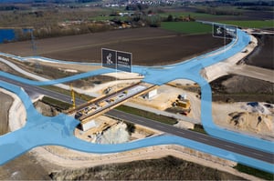
During the optioneering phase, Abley conducts concept designs to advise clients on the most suitable option for their needs. These concepts evolve into preliminary designs, aiding in cost estimation and risk assessment, ensuring informed decisions before proceeding.

Our concept & preliminary design service is often used to support business cases for infrastructure improvements. 

Use cases for MultiNet users: 

  • Integrates and powers location-based services applications used by road controlling authorities 

  • Provides the location awareness to enable geo-marketing and business intelligence 

  • Supports turn-by-turn navigation and routing solutions  

  • Powers fleet and logistics software 

 Features and benefits:
  • Access to high quality maps 

  • Consistent global specification 

  • Quarterly product updates 

  • Additional speed data modules for enhanced analysis 


Book a meeting

Empower your team to analyse location data and make smarter business decisions.

Book a chat with Jacob, our data product specialist who can:

  • Review your specific use case

  • Demonstrate potential data product solutions

  • Answer any questions you might have

Select a day, time and duration that suits you and we'll send you a reminder with all the meeting details.

If you can't find a time/date that suits you on this calendar, then contact us and we can organise an alternative time for you.


Who we are 

Abley is a specialist New Zealand owned transport planning, road safety and geospatial technology company. Founded in 2003, we work with organisations in New Zealand, Australia, Indonesia, U.S., and Canada across central and local government and large organisations.  

We develop transport strategies and infrastructure solutions that support safer travel, improved accessibility, and greater mobility for our clients and in turn, their customers.   

The products and services that we design leverage our expertise in transport planning, engineering, road safety, location data and geospatial systems. 

We are passionate about inspiring positive change. 

Abl23_06-1024x683