Road Safety Dashboard to manage multiple datasets as a single source
of truth
A Road Safety Dashboard created by Abley helps Northland Transportation Alliance manage road safety data in one easy place.
When the Northland Transportation Alliance (NTA) was formed in 2016, they became the roading and transport service department for four district councils: Kaipara, Whangarei, the Far North, and the Northland Regional Council with the support of Waka Kotahi, the New Zealand Transport Agency.
When you’re working with four different councils and a government body, sourcing up-to-date, accurate data for your road safety projects can be tough. NTA decided to create a road safety dashboard for the whole region as a single source of truth. They selected Abley as their road safety dashboard partner because of our track record in developing Mega Maps and working on regional speed management with Waka Kotahi.
NTA Road Safety and Traffic Engineer Vaishali Sankar explains,
Abley’s Road Safety team know their way around the data of Waka Kotahi and have GIS skills to create the customised dashboard we required. They know what they’re doing, which makes our life easier. Once we tell them what we want, we get it. And we’ve a great working relationship. Abley’s Principal Transportation Data Analyst Rebecca Teal-Ireland is amazing to work with.”
How the road safety dashboard is set up
Abley’s lead consultant on the project, and proud Northlander, Rebecca explains,
We’ve created a system where the NTA team can look at risk mapping, speed management, curve risk, and slow street infrastructure all in one place, nicely laid out with handy filters and graphs. We’ve recently added a second dashboard curating data for projects Northland are doing in the active modes space and worked with another consultant to bring all that data into one place.”
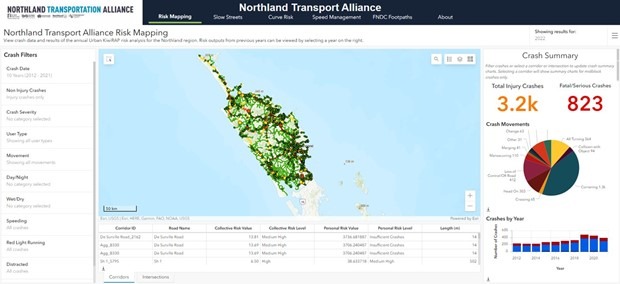
The risk mapping function allows the NTA team to look at the crash risk on corridors across Northland. It includes data on crash history and breaks crashes down by severity so NTA can use filters to understand where different types of crashes occur.
The speed management layer draws on the national speed management work Abley did with Waka Kotahi, collating that data for the region. This is used to prioritise speed management interventions and gives the NTA team more ability to cross reference speed management projects, understand the changes proposed, the criteria assessed, and final outcomes.
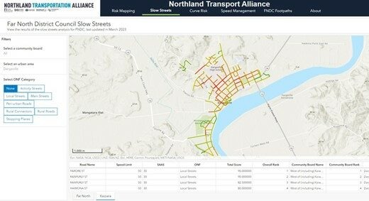
Slow Streets data identifies locations where NTA could consider slow street infrastructure like chicanes and judder bars to slow cars down. It helps the team with forward work programming and allows them to prioritise streets for infrastructure interventions, ranking them across urban areas, community boards, and the district.
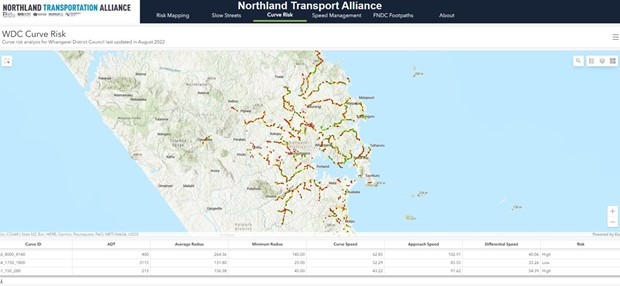
Curve risk has been mapped for Whangarei. Curves are risk rated high, low, or medium using a simple traffic light code. When NTA are planning works they can understand where a curve sits in terms of risk and decide whether to factor additional interventions into their work programme. Abley recently developed a new curve risk mapping process using LIDAR and central line data which allows regions with no high-speed data to map their curve risk.
Finally, about tabs explain why each road is scored the way it is, where the data comes from, and what work has been carried out. This is particularly helpful for new NTA team members looking for background on a particular corridor.
Making applying for funding a whole lot easier
The dashboard makes it easier to access and extrapolate road safety data. Instead of going through multiple databases, we have all the data we need in one place, at a glance. And the dashboard provides a much clearer picture because the map and the graphs are easy to read and to share.”
Perhaps the most valuable thing is the dashboard helps us develop our Regional Land Transport Plan and bid for National Land Transport Programme funding. It makes it quicker to identify key locations where we can apply for funding. The data includes a One Network Framework layer showing street categories and the movement and place elements of each street so it’s straightforward to see which streets fit the criteria from the Safe System intervention toolkit and identify the road safety projects we can bid for.”
The team added data for the Slow Streets programme in Kaipara into the dashboard. That’s really useful for the funding bids we’re working on right now. It makes it quicker to gather the data we need. Otherwise, we’d have to source location data from various sources and cross reference with the Standard Safety Intervention toolkit to see if a project fits the criteria.


Simplifying public engagement and planning
The dashboard also makes it faster for NTA project managers to find the information they need for public engagement. Vaishali explains,
They use the risk map primarily for crash data. The graphs in the risk map are really great because they split the different types of crashes out and provide numbers based on that. That’s really helpful for our project managers because it’s a lot simpler to explain proposed projects to the public with the right numbers.
The other feature I really love is the speed management layer because it’s simple to see what the appropriate speed would be throughout the region. And we can filter by specific region. We get lots of requests from the public wanting to know when speed will be reduced in a particular area. So having one source of truth makes it quicker for us to respond, give people the info they want, explain what the safe and appropriate speed is, and when changes will take place. We’re working on speed management across the region right now, so having the data we’ll use for public consultation is very helpful.”
NTA’s forward works programme is in the dashboard as well. It highlights where current Land Transport Programme works are happening and we can filter based on type of works. It’s easier to see where our next project should be and relate it back to projects we’ve already done. And it makes it really straightforward for someone new to wrap their head around the programme, instead of having to go through terrifying Excel sheets.
"The Road Safety dashboard Abley built is a great tool. It’s a regionwide source of road safety information that everyone is able to use. It’s accessible and straightforward to navigate, with filters you can use to find the data you need. Abley make it very easy to communicate and get everything done.”

NTA Road Safety Dashboard: Curve Risk
Improving the dashboard every year
Northland’s road safety dashboard started with a simple risk map. Since then, we’ve updated the data and added more features every year. Vaishali says,
We’ve a much better, easier access dashboard now. Some improvements have been Abley’s suggestions, And we’ve had ideas like highlighting the key data we need to apply for funding. It’s been amazing working with Abley. They do their part really well, and if we want something we just ask.
If you’re working at a regional level, having a road safety dashboard that’s a single source of truth is a great idea. You can look at everything at the same time. You don’t have to log in to different data portals or go back and forth between different spreadsheets and websites to gather all the data you need.
The dashboard Abley built us is a great tool. It’s a regionwide source of road safety information that everyone is able to use. It’s easily accessible, and straightforward to navigate, with filters you can use to find the data you need. Having the same data available across our whole regional team just makes our job a lot easier. And I want to highlight how accessible Abley is. They make it very easy to communicate and get everything done.”

NTA Road Safety Dashboard: Slow Streets
Could you use a single source of road safety truth?
There’s a lot of road safety data out there. Abley can use that data to help you make wise road safety decisions fast. We know you have a limited budget. We know the factors that impact your decision making. Let’s pull it all together and make your decision-making process simpler and more transparent. A road safety dashboard gives you access to all the data you need to plan your road safety projects in one place. You can visualise the corridors in your region, zoom around, filter data and play with different factors to build yourself a road safety programme that works for you.
If you’d like a road safety dashboard for your region, let’s talk. We specialise in multi-criteria analysis and we’re all about meeting your needs and designing you a system that works for you.
Contact Rebecca Teal-Ireland, who led development of the NTA road safety dashboard, at rebecca.teal-ireland@abley.com.
If you’d like a road safety dashboard for your region, let’s talk. We specialise in multi-criteria analysis and we’re all about meeting your needs and designing you a system that works for you. Contact Rebecca Teal-Ireland, who led development of the NTA road safety dashboard.

NTA Road Safety Dashboard: Risk Mapping
Get in touch
If you’ve got a question or want to chat to us about how we can help you, contact us.
We look forward to talking with you.

