
Proactively assess rural road safety risk
SafeRoads: Identify enables road safety practitioners to assess and classify rural roads into homogeneous segments based on physical and operational characteristics. These segmented roads enable assessment of various variable and attributes that contribute to crash risk laying the foundation for a forward-looking safety strategy, even on roads with little to no crash history.
Make sense of complex data with clear risk ratings
Assess variables including various geometry, speed, and land use variables to calculate a SafeRoads score that reflects expected crash likelihood.
SafeRoads scores are statistically correlated with crash rates, making them a credible predictor of safety risk on rural roads.
Each corridor’s risk score is translated into an intuitive 1-to-5 star rating, making it easy to communicate risk across stakeholders.
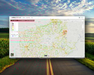
Visualize your road network with confidence
Map and rank the safety performance of your entire road network. SafeRoads: Identify provides clear delineation of homogeneous segments with associated risk scores and star ratings, enabling a data-informed highway safety improvement program to be developed.

Streamline your work with powerful features
Group roads into segments based on name, terrain, or intersection context to ensure a consistent approach to each road.
Evaluate the individual or combined effects of factors like lane width, roadside hazards, alignment, access density, and traffic volume on their contribution to crash risk.
Estimate expected fatal and serious injury crash rates for low-volume or crash-scarce corridors using statistically significant and validated modeled data.