Skip to content
Community & Place

We deliver active modes design, sustainable transport and community engagement.

Digital & Spatial Technology

We create efficiencies with our spatial, software development, and digital engineering solutions.

Road Safety

We support positive safety outcomes from the street to the transport network.

Strategy & Planning

Delivering business cases, traffic modelling, economic assessments, and public transport innovation.

Transport Design & Engineering 

We deliver designs through collaboration with practitioners to shape transport solutions.

Land Development

We apply our transport expertise to support clients through the land development process.

CarbonWise

Measure your employee’s commuting emissions.

SafeSystem

A data-driven approach for road safety practitioners to identify risks.


TrafficFlow

Quickly and easily get detailed traffic and mobility data.

Partner Products

We partner with TomTom and HERE to provide transport and traffic data solutions.


More Products

Discover more of our unique products

Our Insights

Read our insightful blogs providing the latest information and trends.

Featured Projects

The work we do helps inspire positive change.

News

Find out what we are up to. 

Research

Applying our research expertise to provide practical based solutions.

Videos

Explore our Webinars and Video Series.

Our Team

Our team of skilled professionals provide insightful solutions and empowering advice.

Our Story

Since 2003, we’ve been providing transport solutions in New Zealand and internationally. 

Our Commitment

We’re connected and committed to our people, the community and the environment.

Our Partners

We work closely with our partners to make a meaningful impact.

Our Awards

We showcase our awards to celebrate our people and clients.

Aerial view of a simple rural intersection in United States

SafeIntersections: Identify

Locate high-risk intersections to inform smarter safety interventions.

Proactively detect high-risk rural intersections

SafeIntersections: Identify goes beyond traditional crash data analysis, using advanced predictive mathematical modeling to assess risk based on physical and operational factors. By identifying potentially dangerous intersections before crashes occur, our solution enables proactive safety improvements to be implemented where benefits are greatest. 

Making data-driven safety decisions simpler

Prevent Crashes Before They Happen

Proactively identify high-risk rural intersections and implement safety measures before crashes occur. 

Data-Driven Decision Making

Invest in safety with confidence using our extensively validated mathematical model that statistically identifies probable injury crashes.

Targeted Safety Investments

Maximize impact by focusing resources on locations where interventions will provide the greatest benefit.

Defensible Investment Decisions

Support funding requests and project prioritization with scientifically validated data that justifies safety improvements.

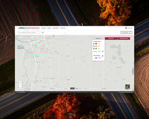
Reveal hidden risks in your network

SafeIntersections: Identify provides instant visibility into high-risk intersections across your road network. Our intuitive interface features color-coded risk ratings and interactive mapping, allowing you to quickly identify problem areas and drill down into specific risk factors at each location. Transform complex data into actionable insights with our comprehensive visualization tools.
SafeIntersections Identify

Streamline your work with powerful features

Comprehensive Risk Assessment

SafeIntersections: Identify analyzes over 50 attributes for each rural intersection, generating a detailed risk profile based on geometric design, traffic patterns, and environmental factors. 

Predictive Risk Model

Our model predicts crash likelihood based on key variables such as traffic volumes, approach angles, and road geometry using advanced statistical analysis.

Risk Categorization

Intersections are automatically classified into three risk classes: 

  • Class 1 – Immediate attention required; highest crash probability 

  • Class 2 – Moderate risk; monitor and plan for improvements 

  • Class 3 – Meets safety standards; minimal current concern

Geospatial Analysis

Efficiently identify and assess intersection risks across your entire road network through advanced geospatial techniques.

Book a call

Book a call with Steve to discuss your organization's challenges and learn how SafeIntersections can deliver effective solutions.