Visualize your critical road network
Upgrade roads carrying 75% of vehicle traffic volume to 3 star or better by 2030.
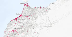
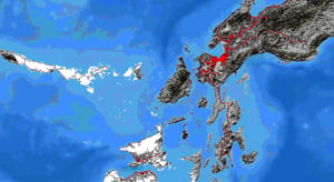
Interactive mapping for network analysis and road safety targeting
Access comprehensive national or regional road network data through our innovative online mapping platform. Identify roads that account for 75% of vehicle travel to prioritize upgrades to 3 star safety standards or better by 2030, aligning with UN targets.
Transform the safety of your road network
Our online mapping platform, using an iRAP-accredited methodology, provides comprehensive national and regional road network analysis. Identify which roads carry 75% of your network's vehicle traffic and require safety improvements to strategically target your road safety investments.
Platform Benefits
Current Data
Access up-to-date road network data at national and regional levels. Stay current with the latest network changes and traffic patterns.
Unified Dataset
Work with a single, aligned dataset covering entire countries. Eliminate the complexity of piecing together multiple data sources.
Cost-Effective Analysis
Save significantly on data acquisition and analysis costs. Get immediate access to processed data ready for strategic decision-making.
Sample Maps
Explore our maps of Morocco, Saudi Arabia, Brazil, Spain and the Philippines to see our platform in action. If you want to learn more, send us an email.
Platform Features
Interactive Mapping Option
National and regional level visualization of your road network.
Critical Network Analysis
Identify critical routes carrying 75% of vehicle kilometers traveled (VKT).
Prioritization of Corridors
Target high-priority corridors for safety improvements and optimize infrastructure investment based on star ratings.
Data Export
Download analysis results for integration with your existing systems.