.png?width=556&height=152&name=Abley_MasterLogo-Website%20(1).png "logo")

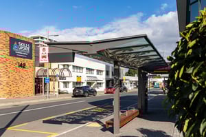
Tauranga, at the heart of the rapidly growing Western Bay of Plenty, is experiencing major economic and population growth. To support this, Tauranga City Council, with regional and central government partners, prioritised improved public transport, requiring major upgrades to services and infrastructure in the city centre.
Read More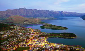
Population growth and tourism are putting increasing pressure on their transport system. For 140 days in 2019, the main route from Queenstown airport to the town centre was overcrowded, causing delays and congestion. Peak day residential population is forecast to grow from approx. 120,000 in 2018 to 200,000 in 2048.
Read More
Abley is proud to be a part of the WX1 bus route improvements journey.
Abley was part of the design review team for the interchanges on SH16 for WX1 and on the only bus priority measure on the arterial link of the WX1 route on Newton Road.
Read More
In November 2020, Abley’s Road Safety team began working with the Victorian Department of Transport’s Safer Roads team to identify suitable statistically robust methods to evaluate road safety projects and programs.
Read More.jpg?width=300&name=shutterstock_592312046%20(1).jpg)
Abley has worked with NZ Transport Agency Waka Kotahi on strategic road safety initiatives since 2012.
We help them make an important difference. And that matters – to us, to Waka Kotahi, and to New Zealand.
Read More
Recently Assurity has committed to becoming a more environmentally sustainable organisation, and part of that is reducing their carbon footprint from commuting. We asked Assurity’s General Manager of Business Services, Tina Burn how CarbonWise supports their sustainability efforts.
Read More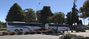
in 2019, Taupō District Council accepted a proposal from Abley to support them in developing their Transport Strategy. The strategy provides long-term direction for council investment in transport services and infrastructure.
Read More
Fulton Hogan specialise, among other things, in building and maintaining roads and transport infrastructure. Abley manages and maintains their GIS technology and supports their Engineering Solutions team with both geospatial system support and digital engineering services.
Read More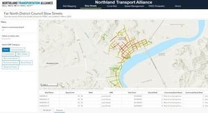
When you’re working with four different councils and a government body, sourcing up-to-date, accurate data for your road safety projects can be tough. NTA decided to create a road safety dashboard for the whole region as a single source of truth.
Read More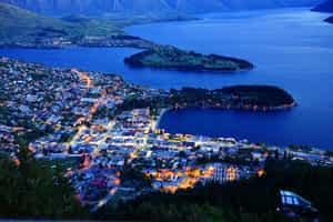
Queenstown Lakes District Council (QLDC) are New Zealand leaders when it comes to taking responsibility for their organisational environmental impact. Their climate action planning is ahead of the game.
Read More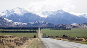
From 2011 to 2021, Selwyn’s population exploded by 66%, making it the second-fastest growing district in New Zealand. This growth accelerated after the Canterbury earthquakes and continues to the present day. Even before the earthquakes Selwyn was growing fast, particularly in the main townships closer to Christchurch.
Read More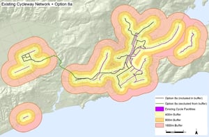
Juggling complex challenges for Dunedin City Council to provide a safer environment for all modes of transport.
Read More
In 2019, Te Manatū Waka, New Zealand’s Ministry of Transport, launched Road to Zero, a 10-year strategy guiding improvements in New Zealand road safety.
Read More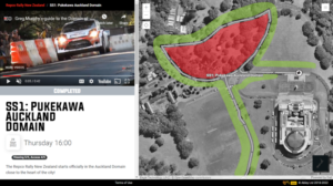
Rally Mapper shows spectators at car rallies the best places to watch the action safely. They get all the info they need to enjoy the event in a handy format they can view on their phone.
Read More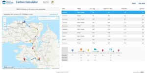
Ports of Auckland give customers more control over carbon emissions from shipping routes in a New Zealand first.
Read More
New Zealand’s Carbon Neutral Government Programme (CNGP) has been set up to accelerate the reduction of emissions within the public sector. Waka Kotahi is one of those organisations committed to the CNGP and reducing emissions.
Read More
Ports of Auckland have a strong focus on measuring and reducing carbon emissions. They came up with the concept of a supply chain carbon calculator as an opportunity to add value to their customers by presenting the carbon impacts of their supply chain.
Read More
MyBallance makes it easier for Ballance customers to manage online ordering and track their use of fertiliser. Farmers can map their farm, name their paddocks, record when and where fertiliser has been spread, create their own fertiliser mixes to fit their unique conditions, and order new agri-nutrients when their stocks are low.
Read More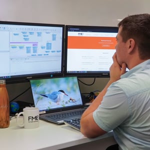
Ballance Agri-Nutrients is a farmer owned co-operative, the largest supplier of fertiliser in New Zealand. Abley’s data technology team supports Ballance through development and optimisation of tools they create for farmers.
Read More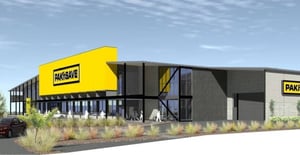
In 2019, Foodstuffs South Island asked Abley to prepare an Integrated Transport Assessment to accompany their resource consent application for a key development in Papanui.
Papanui Pak’nSave is so much more than a supermarket.
Read More
Mackenzie District's small population means the local council’s rates revenue is modest and their roading budget is smaller still. When you contrast the Council Roading team’s resource with the demands placed on the Mackenzie District road network, we begin to see challenges.
Read More

FME is the Swiss Army Knife of digital engineering. It has an almost infinite number of applications, and there’s no situation it can’t illuminate.
Read More
Contact Energy are working hard to help power New Zealand with renewable energy without relying on fossil fuels, committing to net zero generation by 2035.
Read More