TTPSF
Support for FHWA funding applications.
Unlock safer roads for your tribal community
Horizontal curves on high-speed rural roads pose significant challenges for drivers. With over 25% of fatal crashes linked to horizontal curves, addressing these risks is vital to improving roadway safety for your community.
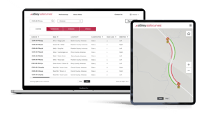
At Abley, we're here to help tribes access insights to enable the development and implementation of systemic roadway departure programs. Our product – SafeCurves, which is also eligible for funding, provides a proven, data-driven method to identify, prioritize, and plan safety interventions aligned with FHWA's guidelines and MUTCD standards.

What is SafeCurves?
SafeCurves is a powerful, intuitive tool designed to help road safety practitioners:

Identify high-risk horizontal curves

Prioritize areas for intervention

Implement safety solutions effectively
Access SafeCurves data through our easy-to-use spatial viewer or overlay the data with your sign inventory or crash records in your own GIS system. Learn more about SafeCurves here.
How can we help you?
Funding for SafeCurves is an eligible activity under the Tribal Transportation Program Safety Fund (TTPSF) Data Assessment, Improvement and Analysis Category. We can help you prepare a Project Narrative to apply for funding to access SafeCurves data.
How can you use SafeCurves data?
SafeCurves can provide key insights to inform your systemic roadway departure countermeasures program, allowing you to prepare an evidence-based application for funding.
Key benefits include:
-
Pinpointing horizontal curves on roads within your network.
-
Classifying horizontal curves into three safety categories based on risk:
-
Class 1 (Unacceptable)
-
Class 2 (Undesirable)
-
Class 3 (Desirable)
-
-
Aggregating horizontal curve risks into homogeneous corridors.
-
Assigning a prioritization level to each corridor for targeted interventions.
-
Identifying appropriate horizontal alignment warning signs and plaques for each curve following MUTCD guidelines.
-
Recommending advisory speeds for each curve based on direction of travel.
Let us help you with your TTPSF application
Navigating funding applications can be complex. Send us an email, and we’ll work closely with you to deliver the information and analysis needed for a compelling submission.
We are passionate about inspiring positive change.
Abley is a specialist New Zealand owned transport planning, road safety and geospatial technology company. Founded in 2003, we work with organizations in the U.S., Canada, New Zealand, Australia and Indonesia, across central and local governments as well as large organizations.


