

 Using LiDAR in transportation planning and engineering" style="object-fit: cover;object-position: center;width:100%;height:100%;" fetchpriority="high" decoding="sync"/>
In our last blog we looked at LiDAR, what it is, where it is used and the differences between Aerial and Terrestrial LiDAR. In this blog we delve a little deeper into how Terrestrial LiDAR is used by transport engineers.
How LiDAR helps the transport industry
One of the most useful benefits of LiDAR derived data is the ability to bring the road to your desk, rather than the other way around. The digital nature of the data captured by LiDAR allows the user to interact and analyse the data in spectacular detail.
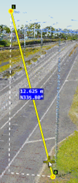
The ability to take measurements from the point cloud (which can have relative accuracies of around 2cm depending on the sensor) is one of LiDAR's greatest strengths. It makes it possible to get an exact measurement of features such as carriageway widths, lane markings, bridge heights, pole lengths and all other features without having to go on site.
LiDAR for measuring volumes and areas
The density of LiDAR data and its ability to account for all the variations in the surface scanned makes it perfect for volume and area calculations. For instance you can calculate the volume of material to be excavated during road maintenance or building operations which helps when estimating construction costs. Entire areas can be mapped out, which is useful when generating quotes for maintenance, such as mowing contracts.

There are software tools and apps that create cross sections of the data which enable more detailed analysis of an area, such as a carriageway. The cross section presents unrivalled detail which can then be measured, interrogated and analysed to further enhance understanding. Useful elements are revealed such camber and super elevation in the case of carriageways and slope in the case of vehicle access points to sites.

Feature extraction from LiDAR data
LiDAR isn't just about direct feature measurement. The LiDAR sensor collects other useful information that can be used for analysis. One such value is intensity, which refers to the intensity or strength of the laser beam return. There are many factors that influence this return strength such as the angle of arrival (scan angle), the range to the surface, its roughness and even its moisture content. One of the most influential factors is the surface material and how it reflects or absorbs light. Reflective materials like the paint from road markings or road signs reflect at a higher intensity. Consequently, it is possible to find these features and extract them from the point cloud.

Feature extractions do not have to stop with road markings. It is also possible to extract features like curbs, traffic islands, road furniture, and others. In many cases, this information can be extracted using automatic and semi-automatic processes with extraordinarily little intervention. In other cases, an experienced human guiding hand is necessary. Nevertheless, using LiDAR data to produce near survey-grade CAD or GIS (Geographic Information System) representations of the carriageway and surrounding environment can be cost-effective way of evaluating a section of the road prior to embarking on construction projects.
LiDAR for data validation
While the previous use cases have focused on data collection, LiDAR data can also be used to validate data that has previously been captured by other means. This could be an asset database of road signs or posts that was captured using aerial photography for example. Due to the precision in which LiDAR data is captured, it can be used to validate the position and existence of these assets in the database and add additional attributes such as height that may not have been previously captured. As LiDAR provides a full scan of the environment, it can be used to determine if vegetation is encroaching on any assets and if maintenance is required to remove the vegetation and/or reposition the asset.
Terrestrial LiDAR has significant benefits:
- There is no need to go on site which saves time and money.
- Your staff are kept safe as there is far less risk to personnel who no longer need to walk on the carriageway to undertake measurements.
- Road users are less affected as traffic management obstructions are reduced or removed.
By supplying very dense and accurate data visualisations, LiDAR brings our road environment to life. Its advantages and uses are endless for professionals working in transport engineering, planning and analysis. Please get in touch if we can help with your next project.