.png?width=556&height=152&name=Abley_MasterLogo-Website%20(1).png "logo")


On Friday 17 June, the Land Development team visited Manukau Bus Station with Debajeet Baruah, Associate Transportation Planner from the Strategy & Planning team. Previously, Debajeet worked at Auckland Transport’s Metro team, the department responsible for public transport infrastructure and services.
The journey to Manukau was on the Eastern Train Line from Britomart, taking advantage of the current half price public transport fares. We passed through new train stations at Panmure, Ōtāhuhu and Puhinui, and alongside the beautiful Waitematā Harbour travelling towards Orakei.
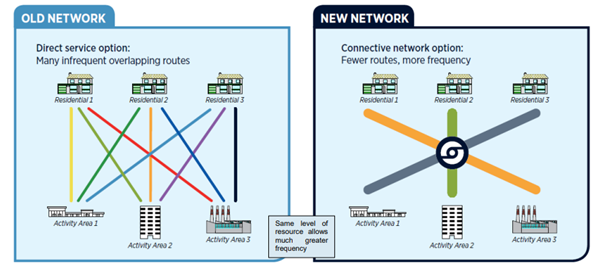
Auckland public transport shifts to hub-and-spoke model
On the way, Debajeet shared key details of Auckland’s public transport and recent shifts from point-to-point route network to the hub-and spoke model, which involves having transport hubs at key town centres and more frequent short trips. These key transport hubs are typically zoned for intensive development as they have excellent public transport connections and enable access to facilities without reliance on the private car.
Manukau Railway Station is in the Metropolitan zone, which permits developments up to 72.5m in height. It’s located directly below Manukau Institute of Technology (MIT), a great example of Transit-Oriented Development in action. The railway station also has an easy walking connection to the nearby bus station.
The main part of our visit focussed on the impressive and newly built Manukau Bus Station which Debajeet worked on the development and design of. Some interesting features of the :
- 23 bus bays, out of which 6 are assigned to InterCity for regional travel.
- High angle sawtooth design with innovative traffic light warning system for reversing vehicles
- ckland bus services located adjacent to the Manukau Railway Station.
- Equipped with essential services, such as coffee, more coffee, and food. And other essentials such as toilets, driver and staff rooms equipped with kitchenette facilities, and storage lockers.
- Real time passenger information.
- Each bus bay had Braille inscription and tactile ground surface indicators to support impaired vision users.
- The entire cost of the bus station was $35 million.

The Puhinui Train Station
After a coffee break in the bus station, we made our way to another impressive hub – the Puhinui Train Station, the main interchange between rail and bus services to the airport.
On the way back to Britomart we did two fun general knowledge quizzes organized by Jack. Side note, it was interesting to learn that the two official languages of NZ are NZ Sign Language and Māori, not English.
Our site visit highlighted the high-quality public transport provision to the Manukau area. It was exciting to see Transit-Oriented Development in action at Manukau Railway Station. In Land Development our primary focus is on ensuring new developments are appropriately located – especially where there is good access to public transport – and that those developments are designed for safe use. Auckland’s Unitary Plan encourages higher density development close to these public transport nodes – exactly as we saw at Manukau Railway Station. It will be exciting to see the developments happening at the three new railway stations currently being developed in Auckland – Te Wai Horotiu (Aotea Square) Karanga a Hape (Karangahape) and the redeveloped Maungawhau (Mt Eden) Station.