.png?width=556&height=152&name=Abley_MasterLogo-Website%20(1).png "logo")


Four and a half years after the Kaikoura earthquake dislodged millions of tonnes of rock onto crucial road and rail corridors linking the lower South Island with the rest of the country, repair work is officially complete. Managed by an alliance of public and private sector organisations, the North Canterbury Transport Infrastructure Recovery (NCTIR) has succeeded in developing a strong and resilient road and rail corridor in North Canterbury and along the Kaikoura Coast.
Abley supported NCTIR in the development and delivery of geospatial (GIS) requirements. The GIS team brought forward technologies to spatially enable NCTIR by developing accessible, centralised, and connected geospatial solutions for internal clients to access and query key datasets. This system enabled the diverse range of discipline experts within NCTIR to work smarter and make better, more informed decisions.
A wide range of technologies were used to provide the required functionality to our internal clients. From custom built solutions, to out of the box configurable apps, the GIS team worked with other teams within NCTIR to achieve the desired outcomes.
System integrations
As with most businesses, there are a variety of different systems and platforms that are critical components of day-to-day operations. NCTIR was no exception, particularly given the range of partners and disciplines involved in the alliance. Numerous disjointed systems had information extracted and combined with other systems.
NCTIR used Salesforce to manage various elements of the alliance, however it was particularly important to ensure that it linked with the financial reporting system. These two systems were entirely separate, with Salesforce operating in the cloud and the financial reporting system existing in-house. Using out of the box integration software, our team was able to develop a nightly process that would download the Salesforce data, convert and map it to the required formats and structures, undertake validation, run data back-ups, and update the tables with the new data.
In New Zealand, road asset information is stored in a system called RAMM (Road Assessment and Maintenance Management). During a construction project like NCTIR this information is required to be entered into the system so contractors are aware of asset lifecycles and any required maintenance. The GIS team developed processes to integrate asset information in RAMM into the internal GIS viewer. This allowed engineers, designers and asset managers to view existing asset information alongside proposed works and other datasets. This provided valuable insight for asset owners as they could identify where assets would exist in relation to other important data sets.
Dynamic catchment generator
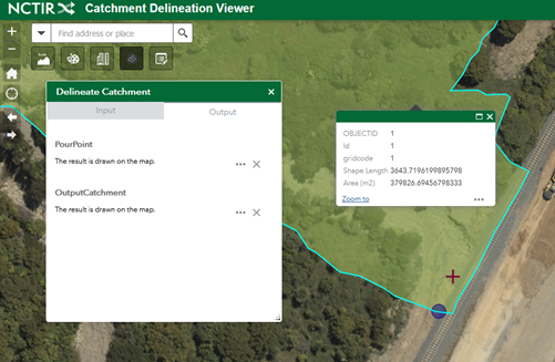
The challenging terrain of the Kaikoura Coast added further complexity to the NCTIR work programme. Steep, rocky mountains lead down to a rugged beach and coastline, often with minimal flat land to accommodate the road and rail corridors. This required significant engineering of the slopes, the road and rail platforms and the seawalls to ensure a reliable, safe and resilient environment.
One aspect that is often overlooked is the management of water coming from the mountains down to the sea. Culverts are used to safely channel the water under the road and rail to the coast. Many existing culverts were significantly damaged and required repairing or rebuilding. To ensure the culverts were fit-for-purpose, the stormwater engineers and designers had to undertake detailed hydrological assessments. While we had access to post-earthquake 1m elevation data, significant manual assessment was also required, which given the complexity of the landscape, introduced potential errors into the design environment.
As part of the NCTIR GIS team, we were able to help streamline this complex process by working with the stormwater designers to build and develop a custom web application that provided them with the tools to quickly and reliably produce stormwater catchments. The GIS team was also provided with over 500 known locations of existing culverts and areas of interest and were able to pre-generate the catchment areas for these. This saved considerable time for the stormwater teams and ensured they had accurate and appropriate outcomes.
NCTIR Street View
Huge volumes of data were also collected as part of the rebuild process. This ranged from your typical survey data, through to drone and aerial imagery and LIDAR, and even locations of archaeological finds such as human remains, shells and fireplaces. NCTIR has identified close to 300 of such locations.
One dataset in particular, intrigued the GIS team.

The survey team commissioned regular 360-degree panoramic image captures of the road corridor. This data set provided an up close and personal view of the earthworks and construction. Initially to view this imagery a proprietary software package had to be installed on user’s machines. This severely limited the ability for people to be exposed to, and to use the imagery, and also imposed a potentially significant cost.
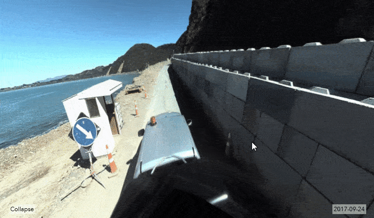
To overcome this limitation and enable more users to see this data, the GIS team developed a custom widget for the internal GIS viewer. This works in a similar way to Google Street View, allowing people to select locations along the road corridor and ‘jump’ into a 360 view of that location. Nine complete surveys were completed in 14 months providing a very impressive temporal dataset of progress along the road corridor. The widget also allowed users to view this data on mobile devices out in the field.
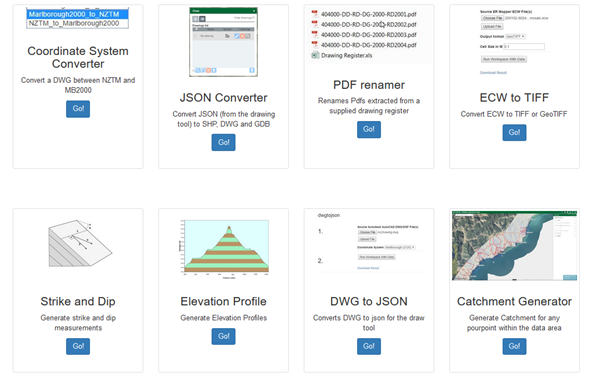
Self-serve GIS tools
The NCTIR GIS team played an important role in supporting other teams within the Alliance. Often the team would field similar, if not identical requests from teams right across NCTIR. This led to the development of self-serve GIS tools.
This collection of tools, found on the internal GIS home page, was built to accommodate common requests. These allowed anyone within NCTIR to get what they required quickly, without having to submit requests to the GIS team and encounter delays. This also allowed the GIS team to also focus on the more complex tasks further increasing overall efficiency.
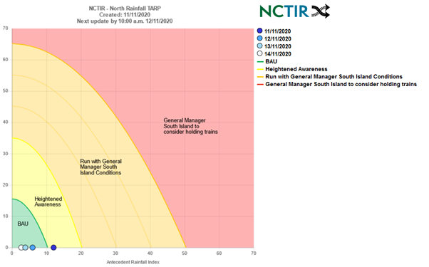
TARP automation
The steep fractured slopes of the Kaikoura Coast were still prone to rock fall and landslides, even after millions of litres of water were poured on the slopes from helicopters trying to dislodge any loose material.
Previous academic research had identified that slopes are more prone to failure when there has been high historical rainfall. This led the geotechnical engineers to develop a formula specific to the Kaikoura Coast that can be used to identify an increased risk of slope failure.
The GIS team, alongside the geotechnical engineers and meteorologists, developed a web-based TARP (Trigger Action Response Plan) that could be used to determine the likelihood of a slope failing and debris failing on the road or rail corridors.
The TARP would give those controlling the corridors an indication of the risk or rock fall and provided them with up-to-date information on the corridor status. Numerous times, the TARP indicated that the corridor should be closed in the coming days; this proactive approach increased safety and reduced risk and cost as often slope failures subsequently did occur but without harm.
3D slips viewer/3D self serve
Having valuable data available to technical people in specialised software is one thing but being able to disseminate that same data to a wider audience adds greater value to the data. The NCTIR Alliance commissioned numerous high-resolution LIDAR and imagery flights along the Kaikoura coast and inland road.
This data was delivered in specialised formats to the GIS, Survey and Design teams. It was typically used in 2D or small areas were exported for construction design. The GIS team saw value in having this data available to all teams at NCTIR. Consequently, we developed a web viewer that allowed users to view this high-resolution data in their browser both on a computer and mobile device. By implementing this tool, the benefit of the high-resolution data was able to be used by all parts of NCTIR.
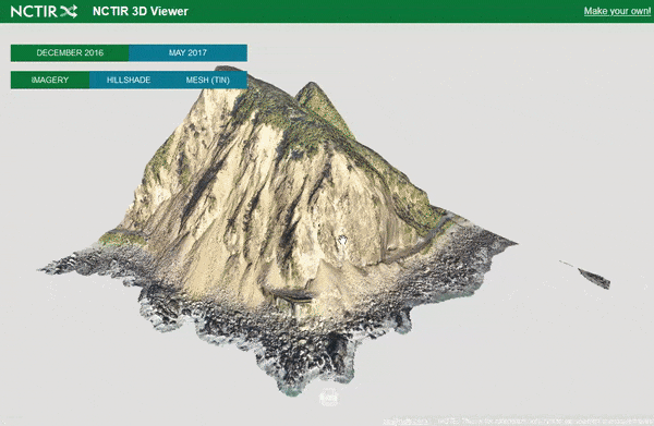
Initially, the GIS team only produced 3D views for all 80 slips along the road and rail corridors. The archaeology team indicated that viewing other sites in 3D to help them identify Maori settlements and structures is beneficial. To accommodate this, the GIS team developed a secondary tool that allowed users to create their own 3D scenes.
This required the user to specify an area of interest and indicate what data they would like included. This was then processed by backend servers and a custom URL passed to the user allowing them to view their area in 3D.
Field data collection
Field data collection was a crucial component of the daily NCTIR workflow; from culvert inspections, through to responding to slope failures and inducting staff onto worksites. Cellular network access along the Kaikoura Coast, inland route and the Hundalees is patchy and limits the use of smart devices to complete field collection.
Using out of the box solutions, the GIS team developed around 80 unique forms for all aspects of the NCTIR Alliance. These forms were closely integrated into existing systems. This not only allowed for data to be updated in NCTIR systems in the field, but also automatically populate form fields based on external and dynamic variables.
For example, when a Geotechnical engineer was responding to a slope failure, the form would automatically populate the current weather conditions. This could be then further refined by the user. Other forms made use of the user’s location and not only displayed their location on a map, but also communicated with network systems that translated the device location to the current section (chainage) of the road and rail corridors.
All of these forms were able to be used offline. Where fields would usually be automatically filled, these were left to the user to populate to their best ability. When the device was reconnected to either WiFi or the cellular network, the completed forms were uploaded and the data added to other NCTIR systems.
NCTIR was a fulfilling and enjoyable alliance to work with. Abley is proud to have been involved in this important project, to help move mountains and reconnect communities.
If you have any questions or would like further information on how we could help your organisation gain clarity or solve problems using GIS, please contact Hamish Kingsbury.
Find out more about NCTIR’s story on rebuilding Kaikoura after the earthquakes.